What Is a Bomb Cyclone? East Coast Lows and the 24 hPa Rule
The definition from the 1980 paper that coined it, how the threshold changes with latitude, why many severe East Coast Lows qualify, and how US nor'easters compare.
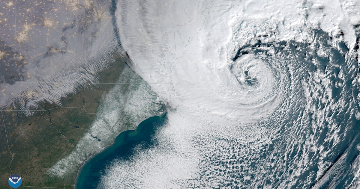
A bomb cyclone is a low-pressure system outside the tropics that deepens explosively: its central pressure falls by at least 24 hPa in 24 hours at 60° latitude, with a lower bar closer to the equator, about 15 hPa at Sydney's latitude. Meteorologists call the process bombogenesis or explosive cyclogenesis, and in Australia the best-known bombs are severe East Coast Lows, such as the low that brought destructive winds and flooding rain to the NSW coast in early July 2025. A bomb is not a tropical cyclone: it runs on the contrast between cold and warm air, while a tropical cyclone runs on warm tropical seas.
Where does the 24 hPa in 24 hours rule come from?
From a 1980 paper in Monthly Weather Review by Frederick Sanders and John Gyakum of MIT, who defined a "bomb" as an extratropical surface cyclone whose central pressure falls by an average of at least 1 hPa (1 millibar) an hour for 24 hours. They studied Northern Hemisphere storms from September 1976 to May 1979 and found bombs to be mainly a maritime, cold-season event. The Bureau of Meteorology describes 24 hPa over 24 hours as a common benchmark that varies slightly with latitude (BOM, 2018).
The latitude adjustment exists because the same pressure gradient drives a different wind at different latitudes, so a storm nearer the equator needs a smaller fall. The formula is:
Pressure fall needed in 24 hours = 24 hPa × sin(latitude) ÷ sin(60°)
The Bergeron is a way to compare storms at different latitudes. One Bergeron is a deepening rate exactly equal to the threshold for the storm's latitude, so a low deepening at twice that rate scores 2 Bergerons. Some later studies redefine the unit, for example as 12 hPa in 12 hours at 45°, so check which version a paper uses before comparing scores.
How big a pressure drop makes a bomb at your latitude?
| Latitude | Example | Fall needed in 24 hours |
|---|---|---|
| 25° | Subtropics | 11.7 hPa |
| 33.9°S | Sydney | 15.4 hPa |
| 40°N | New York City, US | 17.8 hPa |
| 60° | Reference latitude of the original definition | 24 hPa |
The figures come from the formula above, using the latitude of the Bureau's Sydney (Observatory Hill) station. One hPa equals one millibar, so US sources quote the same numbers in mb.
Was the July 2025 NSW storm a bomb cyclone?
Yes, by the standard definition. Bureau of Meteorology pressure charts, as reproduced by Weatherzone, show the low near the NSW coast at 1015 hPa at 4 pm AEST on 30 June 2025 and 991 hPa at 4 pm on 1 July: a fall of 24 hPa in 24 hours. The charts do not give the centre's exact latitude, but that hardly matters: the bar is 15.4 hPa at Sydney and 16.3 hPa two degrees further south, so the low deepened at about 1.5 times the threshold, or 1.5 Bergerons.
The Bureau's July 2025 climate summary records what followed: 224.0 mm (8.8 in) of rain at Ulladulla in the 24 hours to 9 am on 2 July, 331.0 mm (13.0 in) over three days at Jervis Bay Airfield, a 130 km/h (81 mph) gust at Wattamolla, peak waves above 12 m (39 ft) and more than 35,000 homes and businesses without power.
East Coast Lows: Australia's best-known bombs
The Bureau of Meteorology describes East Coast Lows as intense low-pressure systems off the eastern coast, in particular southeast Queensland, New South Wales, far eastern Victoria and sometimes Tasmania. They can form in any month but are most common in late autumn and winter, peaking in June. They often develop rapidly just offshore within an existing trough, helped by the warm East Australian Current, and can intensify rapidly overnight. Gales and heavy rain hit the coast south of the low's centre, while skies north of it can be clear.
Not every East Coast Low is a bomb, but many of the severe ones meet the definition, according to the Bureau (2018). Its examples include the rapidly intensifying low that hit the Sydney to Hobart yacht race in December 1998, killing six competitors, and a low that intensified very rapidly over 20 to 21 June 2016. Bombs also form around southern Australia: the storms that blacked out South Australia's power network in late September 2016 were linked to a rapidly intensifying cyclone. Overall, the Bureau says Australia typically sees several bombs a year, though they don't tend to intensify as rapidly as the January 2018 US storm.
How is a bomb cyclone different from a tropical cyclone?
| Bomb cyclone | Tropical cyclone (hurricane in the US) | |
|---|---|---|
| Energy source | Temperature contrast between warm and cold air masses | Warm tropical seas, typically above 26.5°C (80°F), according to the Bureau of Meteorology |
| Where it forms | Outside the tropics, often off the east coasts of continents in the cooler months | Over tropical or subtropical waters, as a warm-core storm without fronts |
| Defined by | How fast the central pressure falls | Wind: in Australia, mean winds of at least 63 km/h (39 mph) more than halfway around the centre; a US hurricane needs sustained winds of at least 119 km/h (74 mph) |
| Typical lifespan (East Coast Low vs tropical cyclone) | East Coast Low: a few days | Tropical cyclone: about a week |
On a pressure chart the two can look alike. NASA described the October 2021 bomb cyclone off the US Pacific Northwest as having a central pressure of 942.5 hPa, "equivalent to a category 4 hurricane". Storms can also change type: the Bureau notes that bombs can rapidly re-form from a decaying tropical cyclone, the transition covered in our guide to ex-tropical cyclones and New Zealand. For how Australia grades the tropical kind, see how Australian cyclones are named and categorised.
Nor'easters: the US East Coast's best-known bombs
In the US the bombs that make headlines are usually nor'easters. The National Weather Service defines a nor'easter as a storm along the East Coast of North America, named for the northeast winds over the coast. Nor'easters usually develop between Georgia and New Jersey, within about 160 km (100 miles) of the coast, move northeast and typically peak near New England and Canada's Maritime Provinces. They are most frequent and most violent from September to April. How they reach Canada is covered in our guide to Canadian winter storms.
Not every nor'easter is a bomb, but the storm of early January 2018 was. NOAA's satellite service, citing media reports, said its pressure fell at more than twice the 24 hPa (24 mb) rate in 24 hours, ranking it among the most explosive East Coast winter storms on record. It brought accumulating snow to Tallahassee, Florida, for the first time in 28 years, and Boston's tide gauge recorded its highest water level on record. Bombs are not only coastal: on 13 March 2019 an inland bomb set Colorado's lowest pressure on record, 970.4 hPa at Lamar, after a fall of more than 24 hPa in 24 hours, with gusts to 154 km/h (96 mph) at Colorado Springs Airport.
What does a bomb cyclone mean for wind, rain and the coast?
"Bomb" describes how fast a storm deepens, not how strong it ends up. The Bureau of Meteorology stresses that overall intensity matters most for impacts such as strong winds and storm surge. What the speed adds is less warning time, because conditions can turn severe within a day.
- Wind: a deep low has tightly packed isobars (lines of equal pressure on a weather map), and closely spaced isobars mean strong winds. An East Coast Low in 1974 produced a 165 km/h (103 mph) gust at Newcastle, the equivalent of a Category 3 severe tropical cyclone, and drove the bulk carrier Sygna ashore.
- Rain: East Coast Lows bring heavy, widespread rain that can cause flash and major river flooding. In the US, winter nor'easters can also bring heavy snow.
- Coast: very rough seas and prolonged heavy swells cause coastal erosion and inundation. Because East Coast Lows can be slow-moving or near-stationary, their effects usually last longer than those of ordinary lows or cold fronts.
The Bureau covers these hazards with Severe Weather Warnings for damaging winds, damaging surf, abnormally high tides and heavy rain, plus Flood Warnings and Marine Wind Warnings: see BOM warnings explained. In the US, follow your local National Weather Service office.
Why do forecasts of bomb cyclones diverge?
Because the deepening is fast and hangs on small details. The Bureau of Meteorology notes that a bomb's rapid development often makes its exact intensity and timing harder to forecast. In 1980, Sanders and Gyakum found that the operational models of the day fell far short of capturing the observed rapid deepening. A 2013 study of North Pacific bombs in Monthly Weather Review found that even 6-hour forecasts tended to make open-ocean explosive cyclones too shallow, an error linked to too little latent heat release (the heat given off as water vapour condenses) in the model.
Track matters as much as depth. With an East Coast Low the gales and heaviest rain sit south of the centre, so a small shift in where the low forms changes which stretch of coast gets the worst of it. That is why the forecast can change from one model run to the next, and why apps built on different models show different numbers. Our Sydney forecast puts the European, American and German models side by side and rates how closely they agree, and the US forecast page does the same with the NWS, American and European models. When the models split on how deep a coastal low will get, read why forecasts disagree, treat the deeper outcome as possible, and follow official warnings.
A bomb cyclone is a speed test, not a storm type: any extratropical low that deepens by about 15 hPa a day at Sydney's latitude, or 24 hPa at 60°, qualifies. The label tells you a storm is building fast; the forecast pressure, wind and rain tell you how bad it will be.